Wardley Maps for VS Code


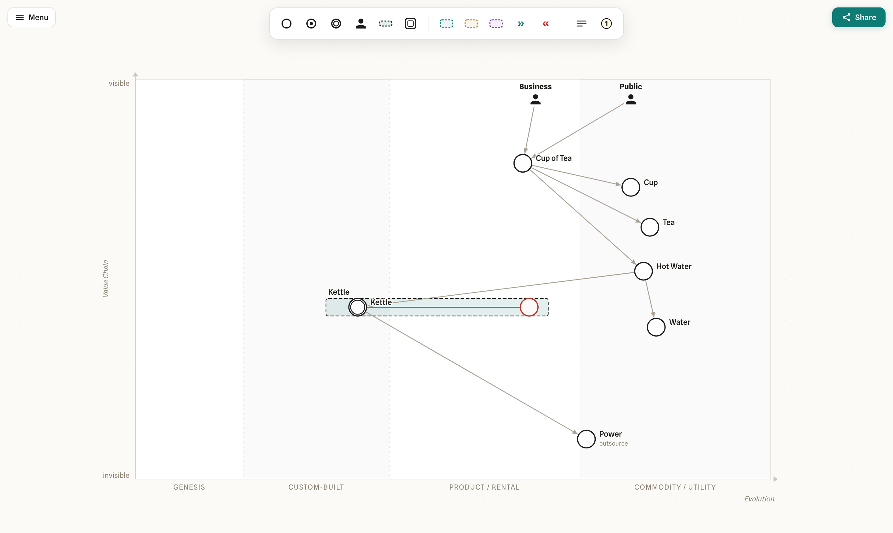
Wardley Maps chart the components of a business by user value and
evolution, so you can see your landscape and reason about strategy. This extension lets you create and
edit them directly inside VS Code: it opens .wmap / .owm files (a simple plain-text format, the
Online-Wardley-Maps DSL) in a graphical editor, while the
text file stays the source of truth, so save, Git, and diff keep working.
New to Wardley Mapping? Start with Learn Wardley Mapping.
Getting started
Install Wardley Mapping Modeler (publisher miragon-gmbh) from the VS Code Marketplace, then
start from a filled-in Tea Shop example or a blank map. The built-in Get Started with Wardley Maps
walkthrough is the recommended first stop: click its Create map from example button and you have a
ready-made map to explore. From there you can open any .wmap or .owm file.
Prefer commands? Run these from the Command Palette (Cmd/Ctrl+Shift+P, type "Wardley"):
- Wardley: New Map from Example — pick a location, pre-filled with the Tea Shop example.
- Wardley: New Empty Map — same, but a blank map (also under File > New File…).
Reading a map
Every component sits on two axes:
- Up and down is the value chain: the higher a component sits, the more visible it is to your user.
- Left and right is evolution: components mature from genesis (brand-new, experimental) on the
left, through custom-built and product, to commodity (standardised, ubiquitous) on the right.
Together they show what you depend on and how mature each piece is.
Editing a map
- Custom editor for
.wmap / .owm. Open a map file and you get the full graphical editor,
backed by the plain-text file. VS Code tracks dirty state, saving and undo as for any text file.
- Text and diagram side by side. The Open Source to the Side button in the editor title bar
opens the text next to the diagram; in the text editor, Open Diagram to the Side does the
reverse. Typing re-renders the canvas live, and a canvas edit rewrites only the lines it changes:
comments, blank lines, statement order and number formatting stay as you wrote them, and the text
editor's cursor stays where it is.
- Problems and highlighting. Lines the parser cannot read (a typo, a link to a missing
component) are underlined in the text and listed in the Problems view; a pill in the
diagram's bottom-left corner shows how many there are and opens the view. The text has syntax
highlighting, and
Ctrl/Cmd+/ toggles // comments.
- Full modeler: the tool palette at the top and the context pad on a selected element (append,
connect, evolve, settings, color, delete). Double-click an element to rename it; placing a new
one opens its name field right away.
Enter on a palette entry places the element in the middle
of the visible map. Drag a component left or right to evolve it, drag its label to move just the
label (Alt+double-click puts it back).
- Map size: drag the plot's right or bottom edge or its corner to resize it (
Shift keeps the
ratio, Alt turns off snapping, double-click the corner to reset), or open Map size… in the
menu for a preset or an exact width × height, previewed on the map as you choose.
- Menu (top left): Map size… and X-axis labels…, Export as PNG, Export as SVG
and Export as PNG (4×, transparent), and Keyboard shortcuts…. Exports are pictures; the
.wmap / .owm file stays the editable source.
- Zoom (bottom right):
−, the zoom level (click for 100 %), + and Fit.
- Empty file: a new, empty map shows a hint and Insert example, which adds the tea shop
example as one undoable edit.
- Invalid file: should a text ever fail to render, the diagram keeps the last valid map
read-only until the text renders again.
- The Miragon modeler chrome (
@miragon/modeler-shell):
the same menu, palette, zoom panel and keys as every Miragon modeler. The diagram stays light in
dark VS Code themes (high contrast themes get the high-contrast chrome) until all Miragon
modelers turn dark together.
- Self-hosted fonts — no CDN, offline-capable. Third-party licenses:
THIRD_PARTY_NOTICES.md.
Commands
Run these from the Command Palette (type "Wardley") or the editor title bar:
| Command |
What it does |
| Wardley: Open Source to the Side |
Opens the map's text next to the diagram. |
| Wardley: Open Diagram to the Side |
Opens the diagram next to the map's text. |
| Wardley: Fit to View |
Zooms the diagram to show the whole map. |
| Wardley: Export as PNG / SVG |
Opens a save dialog (defaults to next to the file). |
| Wardley: Export as PNG (4×, Transparent) |
High-resolution PNG without background, for slides. |
Keyboard shortcuts on the canvas
| Keys |
Action |
C · U · N · P |
Add a component · user · note · pipeline |
A |
Connect from the selected element |
L |
Lasso selection |
Arrow keys (Shift = bigger steps) |
Nudge the selection |
Delete / Backspace |
Delete the selection |
Ctrl/Cmd+C · V · D · A |
Copy · paste · duplicate · select all |
Ctrl/Cmd+Z · Ctrl/Cmd+Shift+Z |
Undo · redo (the file's undo history) |
Ctrl/Cmd+Plus · Minus · 0 |
Zoom in · zoom out · 100 % |
Shift+1 |
Fit the map |
Esc |
Clear the selection, close the menu or dialog |
Keyboard shortcuts… in the menu lists every key and gesture.
Development
Building from source and the dev loop are documented in
CONTRIBUTING.md.
License
MIT
| |